LASRRA - Long Distance Point-to-Point
Wireless link analysis and connectivity report between Alausa (Ikeja) and Library (Sangotedo) for LASRRA network expansion.
Project Overview
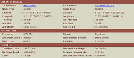
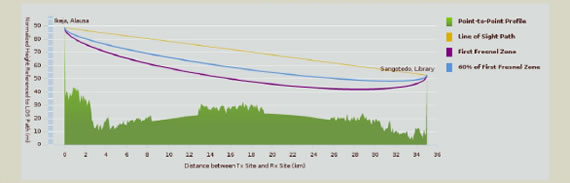
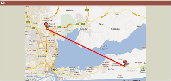
This project involved conducting a long-distance wireless point-to-point link analysis for the Lagos State Residents Registration Agency (LASRRA). The goal was to establish a viable line-of-sight connection between Alausa, Ikeja (Point 1) and Library, Sangotedo (Point 2) using standard field measurement tools.
The assessment was complemented by reference landmarks including Crusader House, Oyingbo, and Tinubu Square to validate the accuracy of the GNSS readings and to enhance coordinate reliability.
Equipment Used: GNSS Handheld Unit (GPS), Compass, Inclinometer, Binoculars
Engineer: Mosudi Isiaka | Email: imosudi@gmail.com, info@mioemi.com
Telephone: +2348098673498
Wireless Link Analysis Report
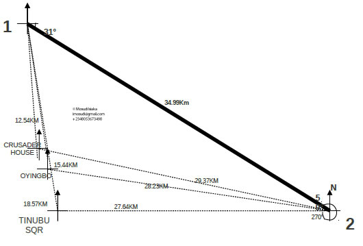
Bearing from Point 1 (Alausa, Ikeja)
- Point 2 → 121° , 34.99 km
- Crusader House → 175° , 12.54 km
- Oyingbo → 173° , 15.44 km
- Tinubu Square → 173° , 18.57 km
Bearing from Point 2 (Library, Sangotedo)
- Point 1 → 301° , 34.99 km
- Crusader House → 281° , 29.37 km
- Oyingbo → 276° , 28.23 km
- Tinubu Square → 292° , 27.63 km
Measurements were verified with GNSS positioning and optical alignment checks.
Project Imagery
Field photographs of both sites and reference landmarks during link alignment.
Technical Notes
A positional error margin of ±25 metres was observed, corresponding to approximately 0.026%, well within the acceptable tolerance of ±2% for long-range GNSS-based measurements. Variations were attributed to atmospheric conditions and the visible satellite constellation at the time of measurement.
Crusader House, Oyingbo, and Tinubu Square were included as reference landmarks for coordinate validation only.
Technologies & Tools Used
- GNSS (GPS)
- Compass
- Inclinometer
- Binoculars
- Topographical Mapping
Link Topology Overview
Point 1] ---|34.99 km / 121°| B[Library, Sangotedo
Point 2] A --> C(Crusader House) A --> D(Oyingbo) A --> E(Tinubu Square) style A fill:#e3f2fd style B fill:#e8f5e9 style C fill:#f3e5f5 style D fill:#fff3e0 style E fill:#e1f5fe